
User account menu

  • Log in
MIT Joint Program On The Science and Policy of Global Change

Main navigation

  • About Us
    • Our Purpose
    • Our History
    • Leadership
    • Personnel
    • Support the Center
    • Contact Us
  • Research
    • Interconnected Systems
    • Modeling and Data
    • Actionable Research
    • Research Projects
  • Publications
    • All Publications
    • Annual Report
    • Global Change Outlook
    • Peer-Reviewed Research
    • Reports
    • Other Publications
    • Publication Search
  • News + Media
    • News Releases
    • In the News
  • Events
    • Upcoming Events
    • Past Events
    • Global Change Forum
  • Sponsorship
    • About Sponsorship
    • Our Sponsors
    • Sponsor Login

Error message

The link "news-item.php?id=76" is invalid. Valid URL's typically start with "https://" for external or "/" for internal links

News and Outreach: Paul O'Gorman

In The News
Scientific American
Jan 25, 2016
The Future of Epic Blizzards in a Warming World

What does global warming mean for extreme snowfall?

Andrea Thompson | Climate Central

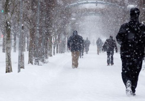
In case you haven’t heard, Washington, D.C., and other parts of the Mid-Atlantic region, are about to get walloped by a major storm that could bury the city in a record-breaking amount of snow.

The storm is expected to bring snows that could top 2 feet in the D.C. area and has already resulted in thousands of cancelled flights. While snows may not be quite as impressive further north, the storm’s fierce winds could whip up significant coastal flooding.

Part of the reason this Snowzilla storm is expected to dump so much snow is because it is pulling abundant moisture. As the planet warms because of excess heat trapped by human-emitted greenhouse gases, the atmosphere can hold more moisture. Scientists already expect heavy downpours to increase because of that. But there’s been little research into what that means for “epic blizzards” like this one.

It might seem that more moisture in the atmosphere along with warming temperatures should mean more rain than snow, and that’s true. But, it turns out, that’s only part of the story.

On Thursday, MIT climate researcher Paul O’Gorman reviewed a 2014 study he conducted that is one of the few to look at extreme snowfalls and warming. Speaking before a group of scientists during a talk at Columbia University, he detailed his use of climate models to look at how extreme snowfalls might change as the planet heats up. Global temperatures have already risen by nearly 2°F (1°C) since the late 1800s.

O’Gorman found that while both average annual snow amounts and extreme snowfalls would decline as temperatures rose, the extremes didn’t drop off as rapidly. Effectively, extreme snowfalls would become a bigger proportion of all snow events.

The reason for this disparity, O’Gorman found, has to do with the very particular temperature conditions in which extreme snows occur, sort of like a frozen version of the Goldilocks tale: If it’s too warm, you get rain, not snow, but if it’s too cold, there won’t be enough moisture in the air to fuel a full-on blizzard.

But looking across a winter, snows in general will occur across a wider band of temperatures—essentially, less warming is needed to chip away at the temperatures that produce all snow than the narrow band where extreme snows occur.

One possible exception to this decrease could be in very cold places, such as the Canadian Arctic, where even with warming it would still be cold enough to snow, but the temperature increase would mean more moisture to fuel that snow.

O’Gorman’s study is one of very few to look at the issue of warming and extreme snowfalls, and, to date, the pattern he identified has yet to be seen in snowfall observations, he said. He suspects this is because there are fewer snow observations than those for rain because snow happens over a much smaller area of Earth’s land surface.

“I don’t expect the signal on snowfall to emerge for another 20 years or so,” O’Gorman said.

That study also only looks at one specific aspect of snowstorms. Another relatively unexplored factor is how warming might influence the storms, called extratropical cyclones, that actually bring the snow as they sweep across the country. Some research has suggested that, like hurricanes, these systems could become less frequent, but those that do occur will be more intense, but it’s still an active area of research.

Discerning any role of warming in fueling this specific storm would require a specific attribution study, but one expected impact of this storm that does have a clear connection to climate change is the coastal flooding it could bring to areas from Maryland up to Long Island. As sea levels continue to rise from global warming, nor’easters and other intense storms are more likely to cause damaging floods.

But for a better picture of what the Snowpocalypses of the future might look like, much more research remains to be done.

This article is reproduced with permission from Climate Central. The article was first published on January 22, 2016.

Photo: 
This NOAA satellite image taken Friday, Jan. 22, 2016 at 12:45 p.m. EST, shows a large strengthening winter storm system that is moving across the southeastern U.S.

In The News
MIT News
Aug 24, 2015
Atmospheric Scientist Tracks Climate Change's Effects on Extreme Storms

Paul O'Gorman: Extreme storm modeler

Jennifer Chu | MIT News Office

Several winters back, while shoveling out his driveway after a particularly heavy snowstorm, Paul O’Gorman couldn’t help but wonder: How is climate change affecting the Boston region’s biggest snow events?

The question wasn’t an idle one for O’Gorman: For the past decade, he’s been investigating how a warming climate may change the intensity and frequency of the world’s most extreme storms and precipitation events.

In 2014, O’Gorman decided to look into how increased warming may affect daily snowfall around the world. In a Nature study that has since been widely quoted, he reported that while most of the Northern Hemisphere will see less total snowfall in a warmer climate, regions where the average winter temperature is near a “sweet spot” will still experience severe blizzards that dump over a foot of snow in a single day.

As it happened, the following winter in Boston produced consecutive blizzards that covered the city in a record-breaking 110 inches of snow, with much of it falling in a single month.

O’Gorman was on sabbatical in Australia at the time, and missed the towering snowbanks, damaging ice dams, and citywide gridlock. But Boston’s extreme winter has spurred a follow-on project for O’Gorman, who recently was awarded tenure as associate professor in MIT’s Department of Earth, Atmospheric and Planetary Sciences (EAPS).

“While I have previously studied daily snowfall, it would definitely be interesting to study these extreme monthly snowfalls,” O’Gorman says. “They obviously can have a big impact in an urban environment, as we saw in Boston.”

“Cross-fertilization of ideas”

O’Gorman grew up in Tullamore, a small town in the midlands of Ireland that, like the rest of the country, receives frequent rainfall throughout the year, but seldom experiences very heavy rainfall or snowfall.

Extreme precipitation was far from O’Gorman’s focus when he enrolled at Trinity College in Dublin. There, he chose to study theoretical physics, and later fluid dynamics, which gave him the opportunity to work with supercomputers to simulate fluid flow — work that earned him a master’s degree in high-performance computing.

At the time, O’Gorman was interested in applying his work in fluid dynamics to problems related to turbulence generated by aircraft. In 1999, he headed to the United States, where he pursued a PhD in aeronautics at Caltech.

“That was a bit of a jump culturally, for sure,” O’Gorman recalls. “One of the nice things is, Caltech is kind of a small place where, like MIT, there’s a lot of cross-fertilization of ideas.”

In fact, O’Gorman’s interest in atmospheric science grew out of just such an opportunity. As part of his studies in aeronautical engineering, he took an elective on turbulence in the atmosphere and ocean, taught by climate scientist Tapio Schneider.

“[The class] totally changed the course of my career and interests,” O’Gorman says.

“I had been studying turbulence on small scales, and now I was learning about turbulence at the planetary scale. What struck me about the fluid flow of the atmosphere was that there are different layers, as well as the rotation of the planet, clouds, precipitation, and radiation all interacting at the same time, and there were a lot of unanswered questions that, to me, were all pretty fascinating.”

After earning a PhD in aeronautics, O’Gorman switched career paths, and worked with Schneider as a postdoc, investigating turbulence in the atmosphere — and in particular, the atmosphere’s response to global warming. When Schneider was invited to a scientific meeting on extreme events, O’Gorman began a research project that ultimately set his course on the study of extreme precipitation.

Climate shift

In 2008, O’Gorman joined the EAPS faculty as an assistant professor, and has since been exploring the relationship between atmospheric warming and the atmospheric circulation and extreme events.

Part of his research continues the work he did as a postdoc with Schneider, in which the two studied climate change’s effect on water vapor: As the climate warms, there is more water vapor in the atmosphere, which in turn acts to further heat the atmosphere. The effect of water vapor and latent heat release has not yet been fully incorporated in existing theories of the atmosphere. O’Gorman says understanding water vapor’s role could help explain how climate change affects rapidly deepening storms at mid-latitude locations, such as the United States and Europe.

While much of his work is based on theoretical modeling, O’Gorman occasionally works with actual weather observations. In 2013, he looked to data collected by weather balloons around the world to see how the atmosphere’s temperature varies with altitude in recent decades. There exists a temperature gradient in the lowest layer of the atmosphere, in which temperatures get colder with altitude. O’Gorman and his student Martin Singh had predicted that as the climate warms, this gradient will essentially shift upward. However, the theory hadn’t been tested with observations.

O’Gorman and Singh analyzed data from weather balloons around the world, each of which took temperature measurements as it rose up through the atmosphere. They found that, based on the measurements, the atmosphere’s temperature profile did indeed seem to be shifting upward over time, consistent with the theory.

“We found if you look at the temperature profile in the current climate, you can predict what it will do in a warmer climate,” O’Gorman says. “This is one of the factors that affects how much radiation is emitted to space, which affects how much the planet warms.”

In the next few years, he hopes to take advantage of the increasing computing power of climate models to track the intensity of rain and snowstorms in response to influences such as greenhouse gases.

“Computers have gotten powerful enough now that we can do simulations of the whole globe, while resolving clouds to some extent,” O’Gorman says. “We can study how convection organizes itself on all sorts of different scales, all the way up to planetary scales. So I think this is a very exciting moment.”

In The News
Boston Globe
Feb 4, 2015
Global Warming Won't Prevent Massive Snowstorms, Study Suggests

MIT Prof. Paul O'Gorman talks with the Boston Globe about how climate change could affect snowfall.

By Carolyn Y. Johnson | Boston Globe

When a historic blizzard dumps a record-breaking amount of snow on the region, it’s only a matter of time before someone ventures a wry joke about climate change. Maybe there’s an upside to a warmer world, after all? Less shoveling.

But the halfhearted punchline doesn’t hold up to scientific scrutiny, according to recent research from a Massachusetts Institute of Technology atmospheric scientist. In fact, a warming world could mean less overall snow in a given year, but no reprieve from extreme snow events, at least in places like Boston.

To science, not all snowstorms are the same: average snowfall is likely to decrease in most places, but the most aggravating, traffic-snarling, work-stopping, back-straining extreme storms like the one that just buried Boston could actually get bigger.

“Most studies have been about how much snow falls in a season or in a year and call that average snowfall. But of course, in terms of disruption to society or economic disruption, we’re also interested in heavy snowfalls,” said Paul O’Gorman, an associate professor of atmospheric science at MIT who published his findings in Nature. “In some regions, fairly cold regions, you could have a decrease in the average snowfall in a year, but actually an intensification of the snowfall extremes.”

O’Gorman published his findings last August, back when snow was far from the front of mind. He is currently in Australia, where the weather is sunshine and showers instead of snow, but took the time to answer a few questions by email about his counterintuitive finding.

Q: Can you explain how a warming climate might affect snowfall?

A: There are two competing effects as the climate warms: the increasing temperature causes a changeover from snow to rain, but it also increases the amount of water vapor in the atmosphere. For a particular place and time of year, which effect wins out depends on the temperature to begin with.

Read more...

In The News
MIT News
Aug 27, 2014
Snowfall in a Warmer World

Study finds big snowstorms will still occur in the Northern Hemisphere following global warming.

Joint Program Logo
MIT News
Aug 17, 2009
A hard rain's gonna fall

Analysis shows climate change to yield more extreme rainfall — Heavier rainstorms lie in our future. That's the clear conclusion of a new MIT and Caltech study on the impact that global climate change will have on precipitation patterns. But the increase in extreme downpours is not uniformly spread around the world, the analysis shows.

Overall, previous studies have shown that average annual precipitation will increase in both the deep tropics and in temperate zones, but will decrease in the subtropics. However, it's important to know how the magnitude of extreme precipitation events will be affected, as these heavy downpours can lead to increased flooding and soil erosion. It is the magnitude of these extreme events that was the subject of this new research, which will appear online in the Proceedings of the National Academy of Sciences this week. The report was written by Paul O'Gorman, assistant professor in the Department of Earth, Atmospheric and Planetary Sciences at MIT, and Tapio Schneider, professor of environmental science and engineering at Caltech. (View article.)

Model simulations used in the study suggest that precipitation in extreme events will go up by about 5 to 6 percent for every one degree Celsius increase in temperature. Separate projections published earlier this year by MIT's Joint Program on the Science and Policy of Global Change indicate that without rapid and massive policy changes, there is a median probability of global surface warming of 5.2 degrees Celsius by 2100, with a 90 percent probability range of 3.5 to 7.4 degrees.

Specialists in the field called the new report by O'Gorman and Schneider a significant advance. Richard Allan, a senior research fellow at the Environmental Systems Science Centre at Reading University in Britain, says, "O'Gorman's analysis is an important step in understanding the physical basis for future increases in the most intense rainfall projected by climate models." He adds, however, that "more work is required in reconciling these simulations with observed changes in extreme rainfall events."

The reason the climate models are less consistent about what will happen to precipitation extremes in the tropics, O'Gorman explains, is that typical weather systems there fall below the size limitations of the models. While high and low pressure areas in temperate zones may span 1,000 kilometers, typical storm circulations in the tropics are too small for models to account for directly.

More...

Pagination

  • First page « First
  • Previous page ‹ Previous
  • Page 1
  • Page 2

Inspired by our mission?

You can help to sustain our research by donating through Giving to MIT (search for fund 2045100).

Contact Information

MIT Center for Sustainability Science and Strategy
Massachusetts Institute of Technology • Cambridge, MA 02139

Follow Us

Quick Links

  • Contact Us
  • CS3 staff & students
  • Accessibility
  • Logout

Main navigation

  • About Us
    • Our Purpose
    • Our History
    • Leadership
    • Personnel
    • Support the Center
    • Contact Us
  • Research
    • Interconnected Systems
    • Modeling and Data
    • Actionable Research
    • Research Projects
  • Publications
    • All Publications
    • Annual Report
    • Global Change Outlook
    • Peer-Reviewed Research
    • Reports
    • Other Publications
    • Publication Search
  • News + Media
    • News Releases
    • In the News
  • Events
    • Upcoming Events
    • Past Events
    • Global Change Forum
  • Sponsorship
    • About Sponsorship
    • Our Sponsors
    • Sponsor Login

User account menu

  • Log in
Back to top