News Release
MIT CS3 presentations highlight multiple sustainability challenges and solutions

MIT CS3 presentations highlight multiple sustainability challenges and solutions
Faculty leaders highlight innovations that can close longstanding knowledge gaps and reimagine how the world responds to the climate crisis
Joint Program researchers contribute to new MIT report on climate, agriculture, water and food security
Joint Program-affiliated EAPS/CEE Prof. Dara Entekhabi and IDSS Research Scientist Sarah Fletcher are collaborators on one of seven projects to receive grants for research on food and water challenges.
'This is not a view shared by us': After MIT professor emeritus Richard Lindzen writes letter urging Trump to withdraw from climate accord, faculty responds.
Related coverage: Climate@MIT, Boston Globe
First year of data from SMAP satellite provides new insights for weather, agriculture, and climate
New technique predicts frequency of heavy precipitation with global warming
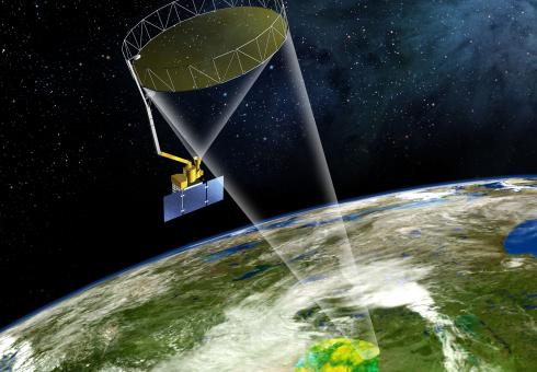
Professor of civil and environmental engineering Dara Entekhabi, science team leader of NASA's SMAP satellite, marvels at the project's first snapshot of Earth.
by Kelsey Damrad | MIT Department of Civil and Environmental Engineering
As severe weather hazards continue to afflict parts of the country to historic extremes, Professor Dara Entekhabi of the MIT Department of Civil and Environmental Engineering (CEE) and a team of NASA scientists provide an unprecedented resource to accurately observe moisture levels within the land for more precise prediction of weather and climate.
On March 4, Entekhabi and NASA’s Soil Moisture Active Passive (SMAP) satellite successfully completed the initial test of its science instruments and revealed its very first image of the Earth’s soil moisture. These “first-light” images were composed of tiny slivers of data in a 40-kilometer line scan and revealed details about the Earth’s soil moisture levels.
During this test, Entekhabi explains, the satellite is not spinning as it orbits the Earth pole-to-pole. As a result, it images a narrow footprint on the ground. Later in March, when the satellite begins to spin as it orbits, the ground footprint will not only have higher resolution but it will also cover a 1,000-kilometer-wide swath.
Specific elements outlined in these early images included a defined contrast between land and ocean bodies. This, says Entekhabi, is a test of the geolocation accuracy. Also over Antarctica, the distinction between ocean, ice shelf, and land ice were clearly evident. Over land, the scattering signature of regions with high biomasses palpably distinguished the sensitivity of the instruments with these early data. For example, the Amazon and Congo forests showed high radar echoes.
“This is just a tiny snapshot of SMAP’s capabilities,” Entekhabi says. “What we are seeing, even in a 40-kilometer line scan, is really remarkable.”
Additionally, the images detected evidence from a variety of known weather phenomena on the ground including Cyclone Marcia — a Category 5 tropical cyclone that occurred in Australia on Feb. 20. This cyclone’s footprint was illustrated in SMAP’s image through low brightness temperatures, a result of its high moisture content in the soil from heavy rainfall.
According to Entekhabi, the amount of accurate data received from SMAP in such an early stage is unparalleled by any other satellite mission.
“Where we are today, with just two days of data, is where other missions are after two years,” said Entekhabi. “Two other existing satellites, SMOS from Europe and Aquarius from NASA, took two years to come to the same calibration accuracy that we saw without any calibration at all.”
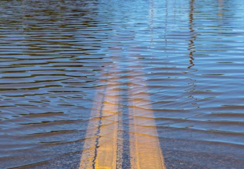
An Earth-monitoring mission initiated in late 1999, SMAP is designed to provide a global map of the moisture content of topsoil and provide meteorologists with a resource to better predict severe weather hazards such as heavy precipitation, floods, droughts, hurricanes, and wildfires.
The satellite is now being maneuvered into its final science orbit, which will take an estimated two weeks.
Reflector antenna unfurled Feb. 24
NASA mission controllers successfully deployed SMAP’s 6-meter-wide reflector antenna on Feb. 24 — a significant milestone in the estimated three-year satellite expedition. To unfurl it, NASA sent commands to the observatory to fire an onboard pyro that would release the stowed antenna, which ultimately engaged the motors and expanded the umbrella-like antenna.
Both the radiometer and radar were activated for a two-day period, during which Entekhabi and his team downloaded detailed data from the satellite and assessed the overall instrument performance. SMAP's science instruments and the deployed reflector antenna, in a non-spinning configuration, underwent their initial operation to view Earth.
Made of a lightweight mesh material, the reflector is the satellite’s preliminary step in its overall mission to provide global soil moisture maps.
“Both the radar and the radiometer performed absolutely flawlessly and beyond the team’s expectations,” he says. “The satellite was only on for 48 hours, and the team was able to process that very limited data all the way through the data systems. This is a testament to the preparedness of the mission team and the motivation to do it so quickly.”
On March 31, the mission controllers will perform their final science configuration by releasing the clutch that holds the satellite’s antenna in place and allow for the satellite spin as it orbits to start. The satellite will then have the ability to scan approximately 1,000 kilometers (620 miles), as opposed to exclusively visualizing the area directly beneath the spacecraft.
According to Entekhabi, this instrumental global soil moisture data acquired by the satellite will also allow scientists to gain a comprehensive understanding of the interconnected nature of Earth's three major cycles: water, carbon, and energy.
“We want a global perspective on the Earth’s water cycle in order to understand how the environment works as well as some of the applications that touch our every day lives,” said Entekhabi. “We want to bring the technical capability to sense the environment to the same level as medical imaging.” SMAP is an embodiment of the lessons taught behind the CEE doors, he continued.
SMAP’s science operations will commence the beginning of May, and provide a high-resolution map of the globe’s soil moisture every two to three days.
MIT professor is lead scientist on three-year mission to study how soil, water, and carbon interact.
David L. Chandler | MIT News Office
Dara Entekhabi, an MIT professor of civil and environmental engineering and of earth, atmospheric and planetary sciences, is the science team leader of NASA’s Soil Moisture Active Passive (SMAP) satellite, scheduled to be launched from Vandenberg Air Force Base in California on Jan. 29. The satellite will provide measurements of the moisture in the top 2 inches of the soil, everywhere on Earth, over the course of its planned three-year mission, as well as specifying whether that water is liquid or frozen. Entekhabi discussed what he hopes this mission will be able to accomplish.
Q. How much of an improvement will SMAP represent over current ways of assessing soil moisture around the world? Why is it important to be able to do so?
A. Why we need soil moisture information, and what capability SMAP adds, can be explained by following a timeline of what we know about how the Earth system works, starting in the 1980s and 1990s.
Until then, the study of the water cycle — the storage and flow of water in the environment — was partitioned between meteorology and hydrology. So long as water was in the form of vapor and precipitating clouds, it was in the domain of meteorologists. Only after the precipitation hit the surface was its infiltration into soil, runoff, and stream flow in the domain of hydrologists.
Around the 1980s there was a transformative change in our thinking, with the emerging capability of fast computers and Earth system modeling. Much of that thinking, in fact, was formed at MIT: We started thinking about two-way interaction and coupling between the land and the atmospheric branches of the water cycle. In order to couple the systems, we soon realized that the key variable to track is surface soil moisture. But the ground networks to observe this variable were too few and far between to yield any meaningful insights. To make global and dynamic maps of this, we had to take on the vantage point of Earth-orbiting satellites. Starting in 2000, I became involved with NASA, and we formed a team to propose a satellite mission whose design is specifically optimized to make high-resolution and high-accuracy maps of surface soil moisture. The paired microwave-radar and radiometer instruments can sense through clouds and vegetation. The rotation of the antenna while orbiting the Earth produces a wide swath of surface measurements that can track changes in soil moisture.
Q. What would you expect to be some of the most significant findings that this mission will be able to make, and what kind of impact could these findings have?
A. With these high-quality measurements, we will have unprecedented insight into how the cycling of water weaves through its land and atmospheric branches. Because the evaporation and condensation of water also entails exchanges of energy, and because the uptake of atmospheric carbon dioxide by plants requires thawed conditions and exchange of water, soil moisture also links the three fundamental cycles of the Earth system — the water, energy, and carbon cycles — over land. These three cycles work together like gears in a clock: Perturbations in one gear will affect the others. If soil moisture were fixed everywhere, these three cycles would vary independently of one another. But with dynamic and responsive soil moisture, the three are linked over land, with synchronized variations. That is a big difference for the Earth system and its cycles. So with observations of soil moisture and improvement in links between the water, energy, and carbon cycles, our understanding of how the Earth system works will be on a new and higher level. With improved characterization and modeling, the predictions of the global and the regional environment — from short-term weather forecasts to global climate-change projections — will be impacted.
Q. How difficult is it to measure these conditions from orbit, and what kinds of tests will need to assess the accuracy of the data returned by the mission?
A. The main technological challenge has been the design of the large antenna and its rotation to make a scan of a wide swath over each orbit. Given the long microwave wavelengths (about 21 centimeters), to focus on a high-resolution spot on the surface the antenna has to be large in diameter. SMAP has a 6-meter lightweight mesh reflector that stows like an umbrella and unfurls in space. Then this large structure has to be rotating at about 15 rounds per minute to map the surface. This is pushing the technology to its limits. We have developed a calibration and validation plan where we pull data in real time from ground sensor networks, perform quality control, and compare with the SMAP data. Over the last two summers we have had two rehearsals of the end-to-end system. The calibration and validation will also include two airborne field campaigns during the summers of 2015 and 2016. Preliminary science data will be released after six months, and after one year we need to demonstrate, using ground-truth observations, that the data meet the accuracy requirements agreed upon by the project and NASA sponsors.
Entekhabi to lead science team for NASA satellite mission
Professor Dara Entekhabi will lead the science team designing a NASA satellite mission to collect global soil moisture measurements and other data seen as key to improving weather, flood and drought forecasts and predictions of agricultural productivity and climate change.
Boosting ethanol production by growing more corn in the United States without considering the quality and availability of water by region could put a significant strain on water resources in some parts of the country, a committee of the National Research Council said in a report released this week.